Background
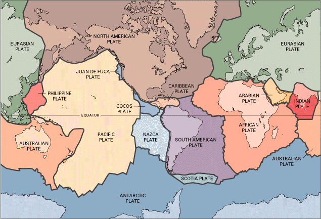 Interest in very dense, spherical satellites for geodetic applications was expressed at the time of the Williamstown Conference (Kaula, 1969), with the recognition that SLR, although still in its infancy, had the potential of cm accuracy ranging. "High mass-to-area, passive satellites, covered with cube corners could sense conservative gravitational forces reflecting the Earth's structure and yet minimize the effect of non-conservative forces, which could be highly variable and difficult to model. These satellites would act as probes in the Earth's gravitational field and therefore their orbital motion would reflect the distribution of mass inside the Earth and in its fluid and atmospheric envelopes. The Earth is an elastic-viscous body with solid and fluid envelopes that are deformed by the gravitational action of the Moon and Sun with a phase lag between their action and the induced deformation. Satellite motion would also include forces due to the gravitational action of the Sun, the Moon and other bodies in the solar system, which would allow us to study these more complex systems. The analysis of orbits of many satellites over long time spans would provide us with a very powerful tool to study tidal phenomena over a wide range of frequencies and time scales." Range measurements at this level of accuracy would allow us to measure tectonic plate motion (continental drift), rotation variations and wobble of the Earth axis, Earth body tides, etc. These objectives could be addressed by measuring time-varying positions of ground stations in a global network of fiducial points on the Earth's surface; the station positions with respect to the Earth's center of mass; and the network with respect to an inertial reference. Variations in these positions were known to have time scales ranging from a day (e.g., body tides) to millennia (tectonic plate motion)."
The passive nature of these "geodetic" satellites and their spherical shape would significantly reduce the spacecraft complexity including the need for stabilization and power, so that missions lasting many decades or even generations could be realized. Its spherical shape would also provide very well defined satellite center-of-mass correction for accurate interpretation of ranging data. These satellites have become the basis for SLR network positioning, gravity field modeling, tide studies, lunar-solar interaction modeling, etc. and eventually the SLR contribution to the International Terrestrial Reference Frame (ITRF) and the estimation of fundamental constants.
Over time, as SLR tracking accuracy continued to improve, analysis of geodetic satellite data would also reveal information about the non-gravitational forces due to the atmospheric drag due to the upper terrestrial atmosphere density and radiation pressure having solar or terrestrial origin, and from the thermal emission coming from the satellite surface itself. To address this host of applications, we need long-term SLR tracking on a stable complex of geodetic satellites, at both high and low altitudes. The optical cross section of these satellites should be as homogeneous as possible with cube corners covering the surface in a uniform pattern. The configuration would be very efficient, reasonably economical to fabricate, and observable over very long periods of time. A well-manufactured sphere would have a well determined center-of-mass for accurate determination of its motion.
The first serious concept considered was the Cannonball Satellite, a 3500 Kg spherical satellite, made from Uranium 238. It was conceived as a back-up payload for the emergency launch vehicle for Skylab, which was to be on the pad, ready to go in case it was needed. Cannonball, a relatively inexpensive, passive payload, could be quickly loaded and launched by the already fueled vehicle if it was not needed for Skylab. Ultimately, the decision was made not to deploy the backup vehicle, and a dedicated launch was sought.
NASA approved the LAGEOS mission in 1974; it was launched in May 1976. The satellite is comprised of a central cylindrical brass core surrounded by two hemispherical aluminum shells that hold the 426 cube corner reflectors. The surface finish was diffuse (chemically cleaned) to provide a good target for optical tracking from acquisition. The retroreflector 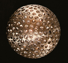 array geometry limited the variation in single point range correction to an estimated 3 mm, due mainly to the multi-cube returns. At the request of Dr. Charles Townes, four germanium cube corners were included in the array for measurements at infrared wavelengths. Because of the high index of refraction of germanium, four cubes give coverage at all incidence angles. Initial optical characterization of the spacecraft was made at GSFC. LAGEOS carries a small plaque designed by Dr. Carl Sagan containing some binary arithmetic and some temporal maps and information about the Earth that might be interpreted some time in the future when and if the spacecraft is recovered.
Orbital acquisition was provided by the Smithsonian Astrophysical Observatory network of NASA supported Baker-Nunn Cameras. The report "LAGEOS Orbital Analysis in Support of Validation", Gaposchkin, 1979 concluded that the LAGEOS satellite has an extraordinarily stable orbit and the objectives for its use can certainly be met.
LAGEOS-2 was a joint ASI/NASA mission built by Alenia Spazio of Turin, Italy for the Agenzia Spaziale Italiana (ASI) and deployed from the Space Shuttle Columbia in October 1992 using the new Italian Research Interim Stage (IRIS) deployment mechanism. The mechanical design of LAGEOS-2 is nearly identical to LAGEOS. Extensive prelaunch testing of the response of LAGEOS-2 to short optical pulses was performed by GSFC (NASA TP-3400, 1993).
The inclination was chosen to provide more opportunities for the SLR ground station observations and to provide the differential node rates to observe the physics goals of the mission. The combination of the two LAGEOS satellites greatly enhanced station sky coverage and provided the foundation for the SLR contribution to the International Terrestrial Reference Frame (ITRF).
Since their launches in 1976 and 1992, and the evolution of SLR to mm accuracies, LAGEOS and LAGEOS -2 have defined the terrestrial reference frame which is the geodetic basis of our measurements of global change over space, time, and evolving technology. They have also contributed to many other areas of Earth science and fundamental physics, including:
- Access to Earth’s center of mass relative to the global network and its temporal variations,
- Measurement of the geocentric gravitational constant (GM),
- Monitoring three dimensional deformations of the solid Earth,
- Monitoring Earth rotation and polar motion,
- Monitoring the temporal variations in the long-wavelength static and dynamic components of Earth's gravitational field,
- Supporting, via precise ranging to altimeter satellites, the monitoring of variations in the topography of the liquid and solid Earth (ocean circulation, mean sea level, ice sheet thickness, wave heights, vegetation canopies, etc.),
- Calibration and validation of orbits obtained from microwave tracking techniques,
- Picosecond global time-transfer experiments,
- Refinement of satellite models for determination of non-conservative forces acting on satellites,
- Gravitational and general relativistic studies, including Einstein's Equivalence Principle and the Lens-Thirring effect.

Over 120 sites around the world have provided laser ranging data from LAGEOS since its launch 40 years ago. Today a network of over 35 stations continue to track the satellite on a daily basis.