LAGEOS Contributions to Science
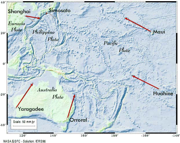
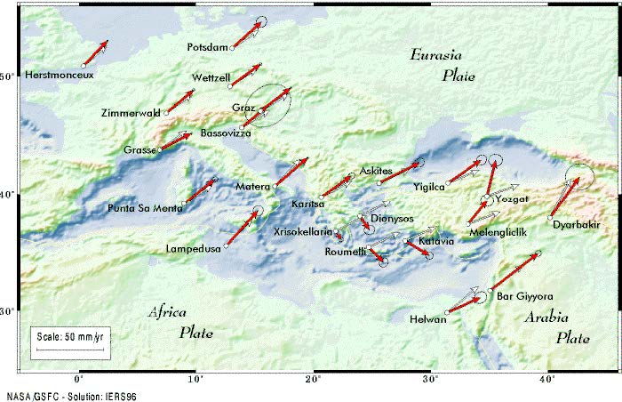
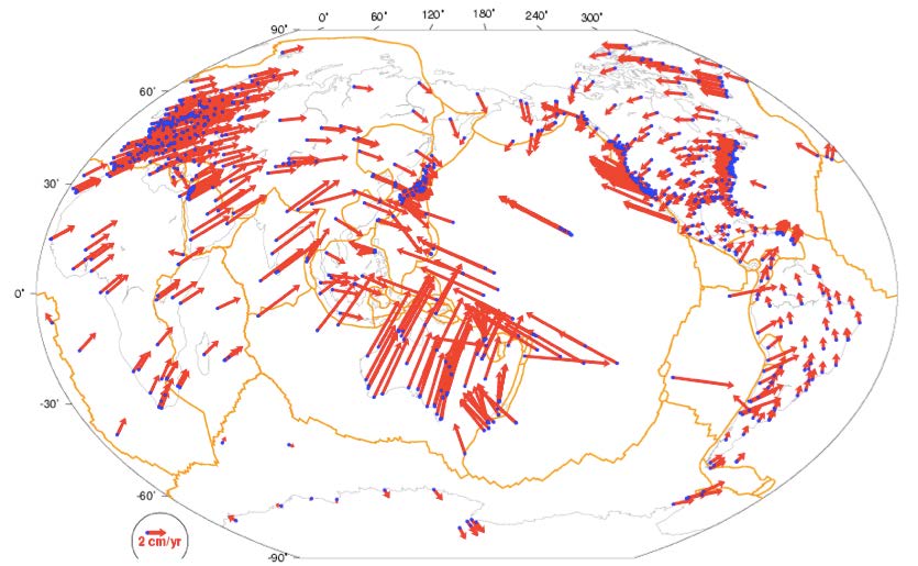
Modern geodesy relies on satellites for precise position determination rather than the stars that astronomers and navigators used in the past. The new beacons are designed to work with the new technology that replaced sextants and telescopes, sometimes relying on radio signals transmitted by the satellites (e.g. in the case of GNSS) and sometimes being passive reflectors of signals from ground-based systems that measure distances to unprecedented accuracy, as in the case of laser ranging. The first such satellite launched by US is LAGEOS—LAser GEOdynamic Satellite, on May 4, 1976. LAGEOS has been used since its launch for positioning of its tracking stations, to monitor the motion of Earth's rotational pole, to determine its gravitational field, to improve our modeling of Earth tides, etc., with extremely high accuracy and at a global scale. One of the prime objectives for launching LAGEOS was to prove through measurements the theory of plate tectonics that had just been accepted by geologists and geophysicists after more than half a century of argumentation since the initial 1912 proposal of Alfred Wegener of a "Continental Drift" theory. Scientists use these high-level products to prove this and other hypotheses, and estimate other geophysical parameters that were never before possible with ground-based measurements alone.
Some of the areas where LAGEOS data have contributed significantly so far and will continue to contribute in the future include:
- Three-dimensional coordinates and velocities of the ILRS tracking stations
- Earth orientation parameters (polar motion and length of day)
- Time-varying geocenter position
- Precise determination of Earth's gravitational mass (GM)
- Static and time-varying coefficients of Earth’s low-degree gravitational field
- Tests of fundamental theories
The accuracy of the LAGEOS design supports a variety of scientific and operational applications including:
- Realization and maintenance of the ITRF, especially its origin and scale;
- Access to Earth's center of mass relative to the global network and its time variations;
- Monitoring three dimensional deformations of the solid Earth crust;
- Monitoring Earth rotation and polar motion;
- Studies of Earth's Chandler Wobble;
- Monitoring the long-wavelength static and dynamic components of Earth's gravitational field;
- Earth's deep interior studies and constraints on deep mantle viscocity;
- The study of non-conservative forces acting on the satellite;
- Charge and neutral drag studies at high altitudes;
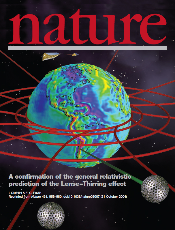
- Gravitational and general relativistic studies including Einstein's gravitomagnetic frame-dragging, also known as the Lense-Thirring effect.
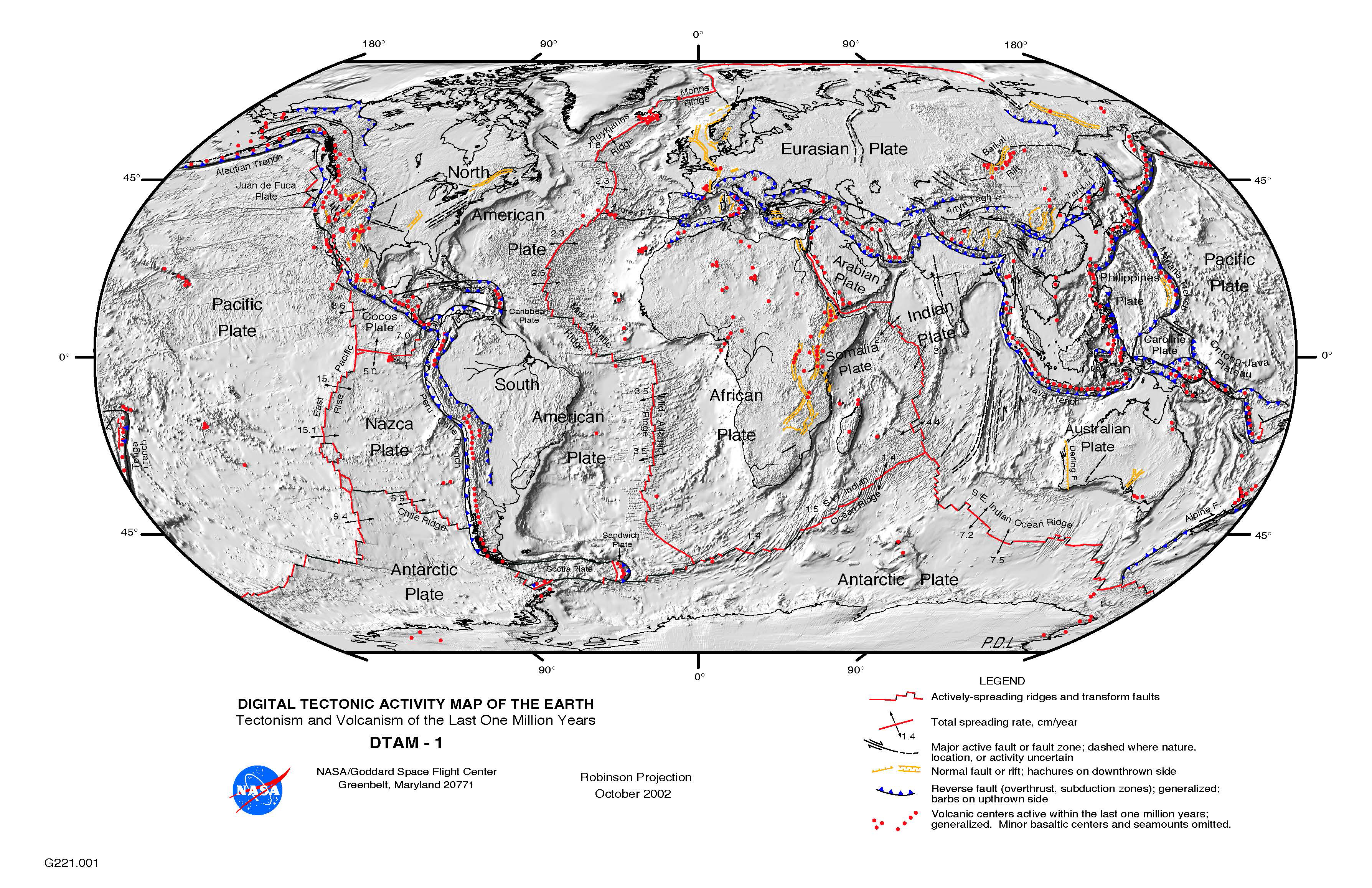
 At the time, the link of plate tectonics and earthquake occurrence had become quite obvious and this is reflected in the official objectives of the mission, hoping "to contribute to development of an understanding of earthquakes, their origin and the ability to forecast their occurrence." The mission design for better than a 10 cm orbital accuracy was not surprising the outgrowth of the deliberations at the famous NASA meeting at Williamstown, Mass., in August of 1969. LAGEOS was the first step of the solid Earth dynamics portion of NASA's Earth and Ocean Dynamics Applications Program (EODAP).
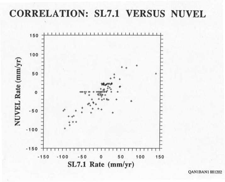
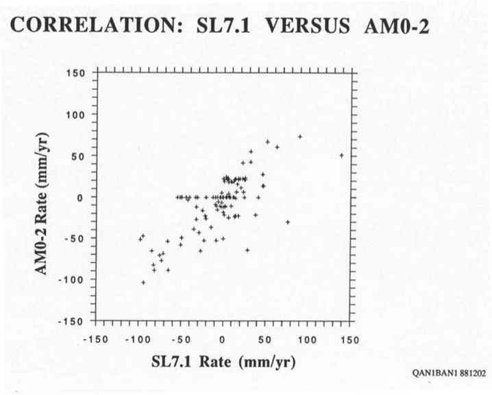
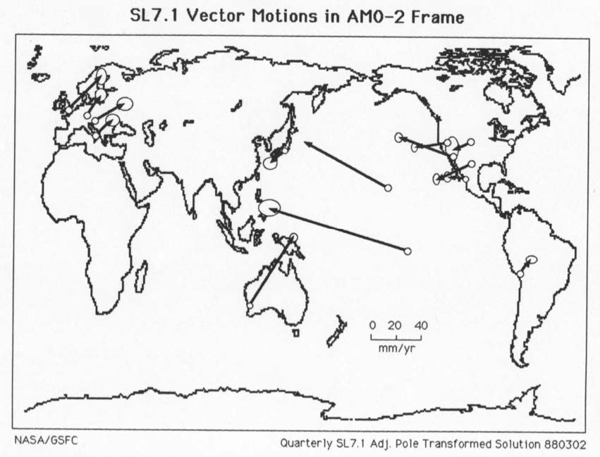
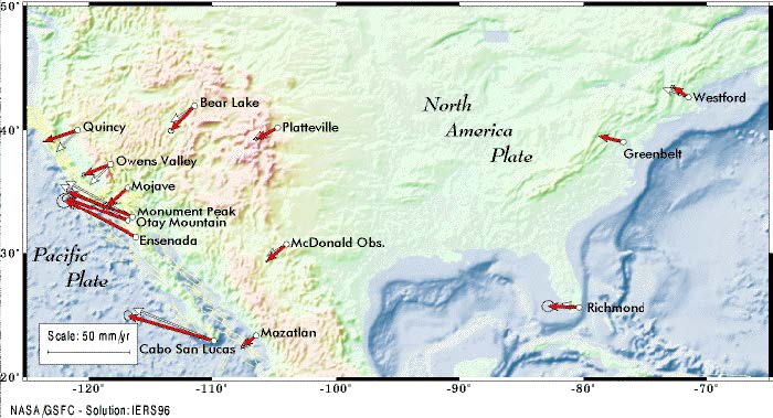 The first decade of the LAGEOS era focused on studying the relative motions of the tracking stations, looking for their agreement or disagreement with the geologically predicted motions. As the network expanded and a more globally distributed set of international stations tracked LAGEOS, it did not take long to use the data for truly highly accurate global reference frame, an improved estimate for Earth’s gravitational constant (GM), the motion of Earth's rotational pole, etc.
As the data accumulated, studies of the long-term evolution of LAGEOS' orbit started revealing unexpected variations that very soon got the attention of scientists worldwide. David Rubincam at Goddard explained nearly all of the observed effects that were for the first time observed on a satellite. As a result, the modeling of LAGEOS' orbit was improved and the analysts became very familiar with the Poynting-Robertson effect, the Yarkovsky effect, the Schach effect, etc.
 With better orbits and more data, the improvement of the gravitational model of Earth's gravity field was the next in line to benefit from LAGEOS. In late 1982, the Goddard Earth Model group under Frank J. Lerch presented their Goddard Earth Model L2 (GEM-L2), after combining the LAGEOS data with what they had used to develop an earlier model (GEM-9). A few months later, Rubincam used the LAGEOS data to observe post-glacial rebound and infer the effective viscosity of the lower mantle. His work was followed by work at JPL and the Univ. of Texas, who established a first estimate of the secular rate of change of Earth's dynamical form factor (J2). Today, LAGEOS, LAGEOS-2 and other spherical laser ranged satellites still provide the most accurate observations of the temporal changes in J2, which we now know that are far more complex than what was initially postulated in 1983.
 Just shy of the 10-year anniversary of the LAGEOS launch, a special issue of the Journal of Geophysical Research of the American Geophysical Union, Vol. 90, No. B11 was dedicated to "LAGEOS Scientific Results". In over two hundred pages, a plethora of exciting results were documented and the volume became a standard reference for many years.
The launch of the Crustal Dynamics Project (CDP) by NASA in 1979 and the successful evolution of this effort to an international one, attracting scientists and agencies from more than thirty countries, made even more use of the LAGEOS data and explored numerous applications and tests of theories throughout the 80s. A collection of the most significant contributions from that period were compiled in a three-volume compendium of AGU's Geodynamics Series (Vol. 23), dedicated to the memory of Edward A. (Ted) Flinn, the former Chief Scientist of the NASA Geodynamics Program, who had led this effort to great success.
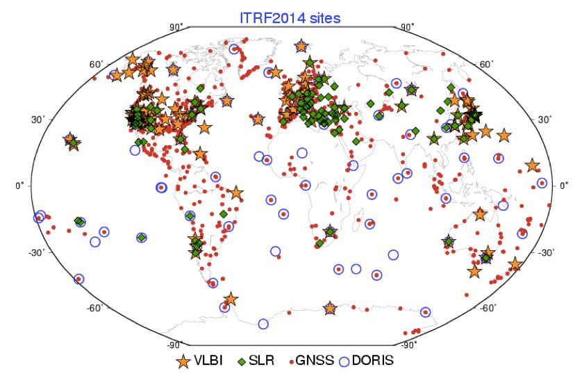
 In subsequent years LAGEOS data improved further thanks to the hardware advances and improved engineering practices around the world, largely thanks to the comradeship built during the CDP years between scientists and engineers the world around. The success of LAGEOS was surely the main force that helped launch the second satellite of its kind, LAGEOS-2, in a close collaborative effort of the Italian Space Agency (ASI) and NASA. These two satellites have become the standard that supports for decades now the development and maintenance of the ITRF. The two define uniquely the origin of the frame that realizes the International Terrestrial Reference System and contribute in equal shares to the definition of its scale along with the Very Long Baseline Interferometry (VLBI) contribution. Although the vision of the LAGEOS project scientists was to see annual station position determinations with an accuracy of a few centimeters compared to the meters obtained from optical tracking networks, the same targets today deliver millimeter accurate positions at weekly intervals and their combination with the other geodetic techniques produces an ITRF model that has an accuracy of a few millimeters in its origin and scale. As the tracking network today moves to the next generation of technology and more targets are launched with improved designs, achieving the goals envisioned by the Global Geodetic Observing System (GGOS) of 1 mm accuracy and 0.1 mm/y stability is only a matter of time.