Celebrating 40 Years of LAGEOS
Friends of LAGEOS and Space Geodesy,
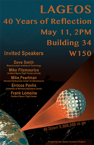
LAGEOS was launched on May 4, 1976. To celebrate 40 years of "operations," tracking, and science we are holding an event on May 11 at NASA GSFC. If any of our colleagues are in the Washington D.C. area we would welcome your attendance at this celebration of LAGEOS and its contribution to scientific research. The event will be held at NASA GSFC at 2:00 pm in Building 34, Room W150. Talks will be from 2:00 to 4:00 PM followed by a social hour. The speakers are:
- Dave Smith (MIT) - The LAGEOS project (slides)
- Mike Fitzmaurice (retired GSFC) - LAGEOS Ground Testing (slides)
- Mike Pearlman (Harvard-Smithsonian Center for Astrophysics)- LAGEOS tracking through the years (slides)
- Erricos Pavlis (UMBC) - Important science results (slides)
- Frank Lemoine (GSFC) - Future outlook: enabled missions and measurements, importance to the reference Frame (slides)
We will have a number of LAGEOS items on display, including the LAGEOS test sector and a replica of the Sagan plaque.
If you are interested in attending, please contact Diana Khachadourian and she will arrange for a visitors badge.
![]() View photographs of the celebration
View photographs of the celebration
Excerpt from "Aeronautics and Space Report of the President, 1976 Activities":
"The laser tracking system used with the Lageos satellite is the newest development in precision tracking and ranging. To apply the science of plate tectonics to studying continental drift and the processes that create earthquakes, precision measurement of slight Earth crustal movements is required. The very stable orbit of the Lagoes satellite provides a reference from which these minute shifts can be determined. Laser tracking is far more precise than conventional high-frequency radio ranging techniques. There are currently four-operating ground stations, three of which are mobile. Using these experimentally with earlier satellites refined the laser system to the point where these stations, and the five additional mobile stations under construction, should be able to obtain measurements accurate to within five centimeters. In addition to providing precision ranging data from Lageos, which will be utilized in studying Earth crustal motion, the mobile equipment will be moved to various locations to calibrate sensitive altimeters on satellites such as Geos and Seasat."
Messages from the LAGEOS community
"Sorry for being so far from DC to celebrate with you all this great anniversary of 40 years of LAGEOS operations and its fundamental contribution to the ITRF. I hope someone will take pictures of the celebration...My best wishes to all."
"I am very sorry that I cannot be on hand. I am sure that Dave, Mike(s), Erricos and Frank will all give an excellent account of the tremendous scientific return of satellites that had (have) no on-board systems. I hope this is a wonderful afternoon. Please convey my best wishes to all friends of 4 decades."
"So glad that there will be a gathering for the 40th anniversary of Lageos' launch! I am sorry to not be nearby, and that I'll have to miss the event. But I'm sure that those who can make it will remember fondly all the good work surrounding the planning, manufacture, launch, data gathering, processing and analyses involving Lageos. It was a pleasure to be a part of the analysis team, given our somewhat rudimentary approaches (at least from today's computing perspective)."